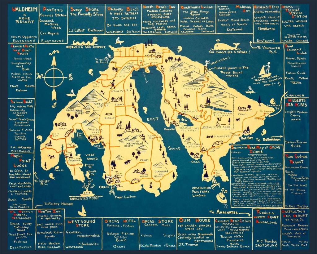
Historic map exhibit at Orcas Island Historical Museum
Published 1:30 am Wednesday, September 1, 2021
by Antoinette Botsford
with Minor Lile
Special to the Sounder
How do you get to Orcas Island? How did the early explorers find their way before they even knew what was there to be found?
The Orcas Island Historical Society’s new exhibition “Mapping Orcas: The Way Home” features an extraordinary collection of maps, most of which were assembled, restored and reproduced by photographer Peter C. Fisher of Orcas Island.
Also featured in the museum are exquisite, hand-drawn, original maps by the late Jean Putnam.
Maps include the township section map (1888-1895) by J.J.Gilbert, a variety of geological and navigational charts, and a number of maps specially created for the “edification” of tourists and amusement of locals.
Also exhibited is a reproduction of a really old map, edited by three explorers in the 18th century, that certainly verifies Juan de Fuca’s 16th-century description of the islands he saw on his voyage to the Northwestern part of the largely unknown continent.
Two mid-nineteenth-century maps by John Wilkes and his expedition show great leaps in the inaccuracy of surveying and navigational methods.
Historical surveying and navigational tools lent by islanders provide support to the maps — and help the viewer to understand how we found our way before Google Earth and GPS were everyday realities in the 21st Century.
Fisher’s beautifully restored maps are available to purchase as reproductions, including sections of the extraordinary Gilbert map, which reveals much about how the land was cultivated and used during the homestead era. A portion of the proceeds will benefit the museum.
A separate cabin in the museum is dedicated to the late Jean Putnam’s hand-drawn, one-of-a-kind watercolor and ink maps of Orcas and the greater San Juan/Channel Islands archipelago that were created for individual clients.
The Museum’s new Executive Director, Nancy Stillger notes that the exhibit will “appeal to a wide variety of people of all ages.”
Stillger looks forward to ongoing collaborative programs that will be offered during the fall and winter months, including talks by mapmakers, storytellers, and historians.
“They’ll all add depth and dimension to the exhibit, encouraging more of the community and visitors to engage with the museum,” she said.
The exhibit officially opens on Sept. 4, the same day as the museum’s WOWZA raffle drawing for the electric car. Further announcements will be made as the day draws nearer and more is known about the danger of the Delta Variant.
The Museum is open Tuesday through Saturday from 11 a.m. – 3 p.m. It’s that cluster of log cabins on North Beach Road, right beside the Village Green. Admission is by donation.